The Critical Role of UAVs in Central Vietnam’s Flood Response
Vai Trò Quan Trọng Của UAV Trong Ứng Phó Lũ Lụt Tại Miền Trung
The historic floods of October and November 2025 have left an indelible mark on the Central and Central Highlands regions of Vietnam, particularly in provinces like Khanh Hoa and Dak Lak. As communities faced rising waters and dangerous currents, a significant shift occurred in disaster management: technology took to the sky. While traditional boats struggled against fast-flowing rivers, Unmanned Aerial Vehicles (UAVs)—or drones—proved themselves as essential first responders.
However, the value of drone technology extends far beyond the immediate emergency. As the waters recede, these tools are becoming equally critical for the second, arguably more complex phase of the disaster lifecycle: rapid assessment and resilient recovery.
Phase 1: The Immediate Response
During the height of the crisis, drones were not just observers; they were active participants in saving lives.
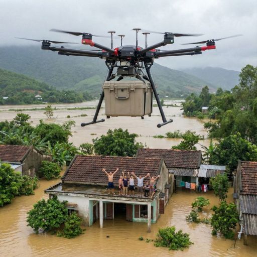
- Logistics & Aid: In isolated communes across Khanh Hoa and Thai Nguyen, where landslides had severed road access, transport drones became lifelines. These heavy-lift UAVs successfully delivered hundreds of kilograms of food, medicine, and essential supplies to families cut off from the outside world.
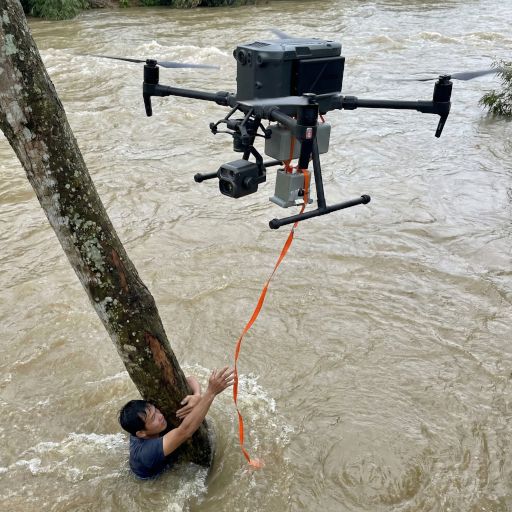
- Search & Rescue (SAR): A defining moment occurred in Ea O Commune (Dak Lak), where a drone was deployed to locate a resident stranded by raging floodwaters. When currents were too dangerous for rescue boats, the drone towed a lifeline to the victim, facilitating a successful rescue.
These real-world applications demonstrated that UAVs are indispensable industrial tools capable of operating where humans cannot.
Phase 2: Recovery and Assessment
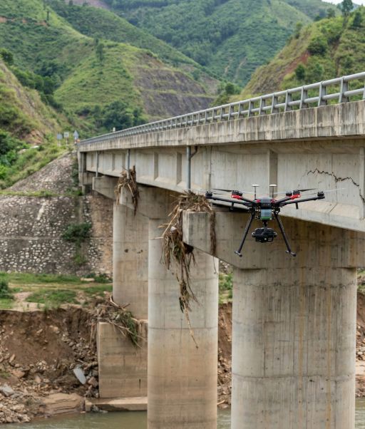
Now, as the immediate danger passes, the focus shifts to recovery. The aftermath of a flood leaves behind weakened bridges, unstable slopes, and damaged energy infrastructure. Traditional manual inspection in these conditions is often slow, costly, and dangerous for engineers.
This is where professional industrial inspection becomes vital.
- Infrastructure Integrity: Drones can inspect the structural health of bridges and roads, identifying cracks, erosion, or scouring that may be invisible from the ground.
- Landslide Risk Assessment: In the mountainous terrain of the Central Highlands, 3D topographic surveys can detect subtle ground shifts, helping authorities predict and prevent future landslides.
- Renewable Energy: For the solar and wind farms prevalent in Ninh Thuan and Khanh Hoa, storms can cause micro-cracks or alignment issues. Aerial inspection is the only way to assess these vast assets efficiently.
How Techstar Western (TSW) Supports the Rebuilding Effort
At Techstar Western, we specialize in turning aerial data into actionable engineering insights. We are not just drone operators; we are data specialists committed to helping Vietnam build back better.
We support the recovery effort through:
- 3D Digital Twin Reconstruction: We create precise, high-resolution 3D models of damaged areas. This allows construction teams and insurers to measure debris volume and plan repairs with centimeter-level accuracy without visiting the site physically.
- Thermal & Visual Inspection: Our drones equipped with thermal sensors can rapidly scan solar farms, wind turbines, and industrial facilities to identify hotspots and storm damage. This ensures critical assets are safe and can be brought back online quickly.
Leveraging our deep understanding of the local terrain and adhering to strict safety standards, TSW provides the critical data needed to restore operations and ensure public safety.
Technology helps us respond faster and rebuild smarter.
If you are an infrastructure manager or property owner facing post-flood recovery challenges, contact Techstar Western today. Let us provide the comprehensive data you need to ensure your assets are safe, operational, and resilient.
Đợt lũ lịch sử tháng 10 và 11 năm 2025 đã để lại những dấu ấn nặng nề tại khu vực miền Trung và Tây Nguyên, đặc biệt là tại các tỉnh Khánh Hòa và Đắk Lắk. Khi nhiều cộng đồng phải đối mặt với nước dâng cao và dòng chảy xiết, một sự thay đổi lớn đã diễn ra trong công tác quản lý thiên tai: công nghệ bắt đầu "cất cánh". Trong khi các phương tiện thuyền bè gặp khó khăn trước dòng nước dữ, Thiết bị bay không người lái (UAV)—hay còn gọi là drone—đã chứng minh vai trò là những "người lính tiên phong" thiết yếu.
Tuy nhiên, giá trị của công nghệ drone không chỉ dừng lại ở các tình huống khẩn cấp. Khi nước rút, những công cụ này trở nên quan trọng hơn bao giờ hết cho giai đoạn thứ hai, giai đoạn phức tạp hơn của vòng đời thiên tai: đánh giá nhanh chóng và tái thiết bền vững.
Giai Đoạn 1: Ứng Phó Khẩn Cấp
Trong giai đoạn đỉnh điểm của thiên tai, drone không chỉ đóng vai trò quan sát mà còn trực tiếp tham gia cứu người.
- Hậu cần & Cứu trợ: Tại các xã bị cô lập ở Khánh Hòa và Thái Nguyên, nơi sạt lở đất cắt đứt giao thông đường bộ, drone vận tải đã trở thành "cầu nối" sự sống. Các thiết bị UAV hạng nặng đã vận chuyển thành công hàng trăm kg lương thực, thuốc men và nhu yếu phẩm đến các hộ gia đình bị cô lập.
- Tìm kiếm & Cứu nạn (SAR): Một khoảnh khắc đáng nhớ đã diễn ra tại xã Ea Ô (Đắk Lắk), khi drone được triển khai để định vị một người dân bị mắc kẹt giữa dòng nước lũ. Khi dòng chảy quá nguy hiểm cho thuyền cứu hộ, drone đã thả dây cứu sinh đến nạn nhân, hỗ trợ công tác giải cứu thành công.
Những ứng dụng thực tế này chứng minh rằng UAV là công cụ công nghiệp không thể thiếu, có khả năng hoạt động tại những nơi con người khó tiếp cận.
Giai Đoạn 2: Phục Hồi và Đánh Giá
Hiện tại, khi nguy hiểm tức thời đã qua, trọng tâm chuyển sang công tác phục hồi. Lũ lụt đi qua để lại những cây cầu yếu, sườn dốc không ổn định và cơ sở hạ tầng năng lượng bị hư hại. Việc kiểm tra thủ công truyền thống trong điều kiện này thường chậm chạp, tốn kém và nguy hiểm cho các kỹ sư.
Đây là lúc dịch vụ kiểm tra công nghiệp chuyên nghiệp trở nên cấp thiết.
- Toàn vẹn Cơ sở hạ tầng: Drone có thể kiểm tra sức khỏe kết cấu của cầu và đường bộ, xác định các vết nứt, xói mòn mà mắt thường khó nhìn thấy từ mặt đất.
- Đánh giá Nguy cơ Sạt lở: Tại địa hình đồi núi Tây Nguyên, khảo sát địa hình 3D có thể phát hiện các dịch chuyển đất nhỏ nhất, giúp cơ quan chức năng dự báo và ngăn chặn sạt lở trong tương lai.
- Năng lượng Tái tạo: Đối với các trang trại điện mặt trời và điện gió phổ biến tại Ninh Thuận và Khánh Hòa, bão lũ có thể gây ra các vết nứt vi mô hoặc sai lệch kỹ thuật. Kiểm tra từ trên không là cách duy nhất để đánh giá hiệu quả các tài sản quy mô lớn này.
Techstar Western (TSW) Hỗ Trợ Tái Thiết Như Thế Nào?
Tại Techstar Western, chúng tôi chuyên biến dữ liệu từ trên không thành các thông tin kỹ thuật có giá trị hành động. Chúng tôi không chỉ là đơn vị vận hành drone; chúng tôi là các chuyên gia dữ liệu cam kết hỗ trợ Việt Nam tái thiết mạnh mẽ hơn.
Chúng tôi hỗ trợ nỗ lực phục hồi thông qua:
- Tái lập Bản sao Kỹ thuật số 3D (Digital Twin): Chúng tôi tạo ra các mô hình 3D chính xác, độ phân giải cao của các khu vực bị hư hại. Điều này cho phép các đội xây dựng và bảo hiểm đo lường khối lượng đất đá sạt lở và lập kế hoạch sửa chữa với độ chính xác centimet mà không cần trực tiếp đến hiện trường nguy hiểm.
- Kiểm tra Nhiệt & Hình ảnh: Các drone được trang bị cảm biến nhiệt của chúng tôi có thể quét nhanh các trang trại điện mặt trời, tuabin gió và các cơ sở công nghiệp để xác định điểm nóng (hotspots) và hư hại do bão. Điều này đảm bảo các tài sản quan trọng được an toàn và có thể được khôi phục vận hành nhanh chóng.
Tận dụng sự am hiểu sâu sắc về địa hình địa phương và tuân thủ nghiêm ngặt các tiêu chuẩn an toàn, TSW cung cấp dữ liệu quan trọng cần thiết để khôi phục hoạt động và đảm bảo an toàn công cộng.
Công nghệ giúp chúng ta ứng phó nhanh hơn và tái thiết thông minh hơn.
Nếu bạn là quản lý cơ sở hạ tầng hoặc chủ sở hữu tài sản đang đối mặt với thách thức phục hồi sau lũ, hãy liên hệ với Techstar Western ngay hôm nay. Hãy để chúng tôi cung cấp dữ liệu toàn diện bạn cần để đảm bảo tài sản của bạn an toàn, vận hành tốt và bền vững.
Drone flood relief Vietnam, UAV disaster response, post-flood damage assessment, Techstar Western, drone inspection services Vietnam, 3D digital twin, thermal inspection solar farm, infrastructure survey.